Section of the aeronautical chart showing the area and airspace
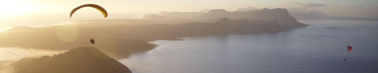
Great PPG flying on the West Coast today. We met at Grotto Bay and flew north along the coastline to Yzerfontein – 30km of almost uninhabited and deserted beach, with the occasional wild ostrich for company. After an extended coffee break at Yzerfontein to assess what the wind was doing (a NE land breeze meeting the forecast NW sea breeze) the general consensus was to head back to Grotto rather than chancing a flight to Langebaan. Fortunately, help was at hand in the form of Dave, who offered to drive my Pajero as a support vehicle, and so I invited him to drive it all the way to Blouberg, said goodbye to the others at Grotto Bay and flew the whole stretch back in one go – more than 70km cross-country flight if you allow the small detour around the Koeberg Nuclear Power Station restricted airspace which I had to make.
27 April in South Africa is Freedom Day, celebrating the anniversary of our first democratic elections 18 years ago. Seeing that I was on call for the night shift, I had the public holiday available for whatever recreation beckoned. What better way to celebrate freedom than by flying, unhindered and free as a bird? Cue hang-gliding montage…
Driving to SLP, just visible above the white car
The wind looked promising for flying at Sir Lowry’s Pass, where the highway from Cape Town exits over the Hottentots-Holland mountains to begin it’s route up the country’s east coast. SLP ( as it’s colloquially known) offers a few different launch sites for paragliders and hang-gliders, with the main (but most tricky) site being at the viewpoint where the highway crests the ridge at about 450m ASL. Here the wind is channeled through a gully, past several rock outcrops that have claimed their casualties over the years, and over a small eroded patch of grass barely large enough for one glider at a time. A well-executed launch and nimble right bank allows one to soar the inevitable lift along the road and rail embankment and nearly guarantees an immediate climb to the ridge-top, where it can be remarkably thermic and long out-and-return runs are possible. A botched lauch ends at best in an 8-minute glide out beyond the power lines to the landing field at the bottom of the pass; at worse one ends up adding your score in blood to the rocks. For the more cautious, a friendlier top launch suitable for paragliders is about 15-20 minutes walk away; hang-gliders can carry 5 minutes down to a lower take-off below the highway. I’m not convinced either of the ‘safe’ options add much real safety by the time you have factored in crossing a multi-lane mountain pass highway on foot…but that’s another subject.
Carrying gliders to the lower launch
Paul (another biwingual who mostly flies HG these days) and I met up in the landing area around midday. The wind was northerly but going NW, and the forecast good. We decided to use the bottom takeoff, which given the wind strength at the top was a good call. The neatly trimmed fynbos on the steep launch has been growing back in force, which makes both rigging and launching a challenge, but after half an hour of toil I was ready to go – Paul, being a gentleman, uttered something to the effect of “Looks good: you can go first.” It felt a tad silly to don three layers of clothing and then gloves and a pod and then stand there in the sun with little breeze waiting to launch fully expecting a sled glide to the landing field, as the wind seemed to have backed off.
Rigging at the launch area
I waited a few minutes for a promising cycle and then ran hard at the protea bushes a few meters ahead of me. Bless her: the Sonic scooped me up and wafted into the air with ease. My vario gave a delighted squeal as I banked left into the bowl and let the bar ease out from takeoff speed, and then settled into a steady beeping. Climbing! Within a minute all thoughts of a short flight were erased as we effortlessly left the ridge below and flew out into a good thermal. I thought I’d test out the air while waiting for Paul to launch, but as I steadily climbed I set a lazy course west towards Gordon’s Bay and settled into the flight. I could see his glider on the slope…clearly he’s still getting into his harness.
Approaching the end of the ridge, with the Gordon's Bay pump station (a PG launch site) visible on the left)
Despite not being a pre-frontal NW, the wind had a pronounced gradient, and at above 800m ASL on trim speed I found myself going backwards. Paul’s glider was still on the ground, so I pulled in to a comfortable speed and carried on down to the end of the ridge, about 10km from takeoff. The view was beautiful: Steenbras Dams and the Kogelberg mountains to my left, the whole of False Bay under puffy clouds to my right. Flying accelerated along the ridge was tiring, however: the Moyes Sonic is not VG-equipped and maintaining a good speed requires a fair amount of input. Also, my harness was not locking nicely in a prone position, which meant I had to keep pushing with my legs to stay flat. Beyond Gordon’s Bay I decided to use some of the height flying out over the sea to the north and then looping back towards the ridge later, thus hopefully staying out of the stronger winds. By now Paul’s glider was no longer visible, so I presumed he had launched and was chasing me.
Gordon's Bay from the airApproaching cloudbase with False Bay laid out in front of meThe Helderberg Valley from 1000m ASL
One great thermal near Gordon’s Bay took me back to cloudbase, so I set off on glide straight for SLP. Along the way Paul and I found each other; he’d been able to fly a lot quicker on his VG-equipped Airborne and had caught up easily. Without radio comms (his is still in creation) we couldn’t discuss plans. I thought I’d try a jaunt to the east to the big mountains, not knowing that he’d already been a few kilometers that way and had encountered a strong headwind and turbulence. I met this with vigour to the east of the pass. Somewhere in a rowdy thermal, my extra pressure on the kick-stap to maintain prone position snapped the cord, leaving me in a semi-upright high-drag position. This is not pleasant for flying, adding considerable strain on the arms in the lumpy air. One particular strap was also pressing into my upper abdomen, and after a few minutes I began to feel a little queasy. After touching it out for while I decided that it wasn’t fun anymore and headed down to the landing field. It was still quite thermic on the ground, turning my landing approach into a dolphinesqe dance of blips and dips. Paul saw me landing and thought it was due to a rush to get to work, so he came down too, perhaps more gracefully as the clouds moved in and the land cooled off.
Heading back to SLP
What a great day for flying. Paul, who has flown HG at the site for many years, reckons it could have been a day to fly further down the coast, across Kogel Bay and all the way to Cape Hangklip. Something for next time, certainly! I’ve got some video clips which I’ll try get into a useful format ASAP…and will soon have to replace the sunken GoPro, as this kind of flying is not conducive to one-handed snaps!
The landing field at SLP. How does hang-gliding make you feel? The t-shirt says it all!
Yowzer…I loaded the same pictures from my last post onto Facebook last night, and the response has been phenomenal. Imagine my surprise when I get a forwarded forwarded forwarded email from the surf community including my picture as evidence of a huge shark terrorising the surfers at Noordhoek! Well, lads and lasses, a big shark it was, but the terror is misplaced: you can’t see it well on the Facebook photo, but it’s a gentle giant – a Whale Shark. That makes it much more special than “just another” Great White (something I prefer to see from the air than the water, unless I’m on the bottom with a regulator in my mouth), as a sighting of a Whale Shark in the Atlantic is rare. Wikipedia will tell you all about them and their tropical/subtropical range – seldom south of 30 degrees – but I was very tickled to learn that the species was first described when one was harpooned in Table Bay. Yay for African science, bummer for environmental consciousness.
A couple of pictures from the flight:
Kommetjie from the air3000ft on the powered paraglider, working on my sunburnLots of surfers in the water at NoordhoekWhale Shark and surfers
There’s been some bruhaha about the species and size of the shark, so I referred it to our guru, Johan Anderson, of Wings and Whalesharks fame. Johan flies all sorts of things (and is the man behind the Zee PHG pictured above), but one particular project of his is flying a microlight in the Seychelles for whale shark research and spotting program. He confirms that it is indeed a whale shark (not a great white) and not quite the 7m monster suggested by some sources. As whale sharks grow to around 12m, this is a smallish specimen. For comparison, I’ve cropped together (at precisely the same scale) the shark and surfers, so that you can decide for yourselves.
Whale shark and surfers cropped to the same scale
What a great sighting, and a lovely flight.
Heading back to Hout Bay at 3500ft to avoid the turbulence from the mountains
UPDATE: This just in – get the story from the surfer’s seaside perspective on the Wavescape website, as well as some expert opinion from more shark experts. Compelling reading…I can imagine the guys in the water had a good tachycardia.