My good mate Ant of The Aerial Perspective was very kind to invite me along to Greyton, where he needed to take some pictures. We cruised out there in the Vito early this morning to find the town dead still (wind and street-life) with heavy dew on the ground, and so we stopped at a local coffee shop for tea and toast. Greyton is as pleasantly bucolic as I remember, albeit somewhat more developed these days.

After completing consumption of our comestibles we went looking for a launch area. The Greyton Sports Club had a nice field, but it was still very wet and surrounded on three sides by trees. A foray down the other end of town was more fruitful…well, too fruitful, in fact. Not only did we find a great little field, which was slightly raised and offered a puff of wind, but it was also downwind of the dump and sewage settlement ponds. To complete the scene, a large herd of splendidly flatulent bovines stood contemplating us from over the fence. Perfect. Although the field was small and the ponds large, the light wind was conveniently blowing across the corners, offering a decent run and space to climb out. We rigged quickly, and then I helped Ant launch so that he could get the photography done quickly. I was rapidly ready to go, and then in my enthusiasm flooded my engine and had to take if off to get it restarted. By that stage, the wind had almost disappeared, and what little remained was now blowing directly over the ponds, across the short axis of the already short field. Eish.

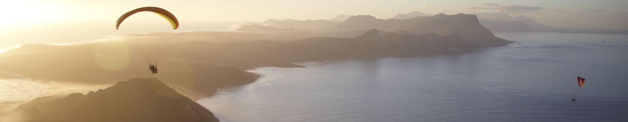
I have plenty of faith in my Speedster to lift off quickly and keep flying through all sorts of cr@ppy air, but exiting over actual excrement was a new one for both of us. Needless to say (as Ant’s photo will attest) we slipped the surly bonds of earth before they became faeculent and were soon dancing the skies on sweeter smelling winds. The photographic work was done within a few minutes. The sun was now beginning to make itself felt on the farmlands, and we were flying in and out of thermic bubbles strong enough to upset the non-PG PPG crowd, but I was still very happy. Ant kindly offered to drive retrieve should I wish to keep flying, and so I filed my “IFR (I Follow Roads)…see you somewhere near Botrivier” flight plan and set off.

The lumpy air over the farmlands and hills encouraged me to fly low along the Riviersondered River, where the view was interesting and the air still a bit cooler and smoother. Trims open and with a light easterly tail-wind, the Speedster was cruising at 75-80km/h ground speed. The sights as I progressed upstream were lovely: farmhouses with dogs loping along, orchards and plowed fields, flock upon flock of Egyptian and Spur-winged Geese, and three pairs of Fish Eagles. Past Helderstroom I was tempted to fly up the gorge to the Theewaterskloof Dam wall, but a combination of concern regarding the upper-level winds (clouds showed evidence of a strong northerly, and Ant later reported whitecaps on the dam itself) and not wanting to cause airspace upsets near a major dam discouraged me. Forced to leave the Riviersonderend, I climbed (aided by some thermals) up and over the ridge bearing the R43, and then dropped down the other side into the Botrivier valley. Here the southeaster was beginning to make it’s presence felt; I didn’t feel the compulsion to let the trims out again, as we had a few small collapses and one decent 40%-er flying over a rocky ridge. Definitely an area in which we need to try more PG XC!

The flanks of Houwhoek mountain begged to be soared; I allowed the engine to idle and climbed gently over the fynbos for several minutes while crossing the broad face. The town of Botrivier presented itself quickly, and I overcame the temptation to continue up onto the Elgin plateau when I turned into wind and found my ground speed drop to a snail’s pace. Botrivier presented a landing option in the form of paired rugby and soccer fields, and I gratefully accepted, landing gently after just more than an hour and ~55km (~45km straight-line) distance covered. What a great flight!

Photographs of the author courtesy of Ant Allen, copyright The Aerial Perspective
You must log in to post a comment.