Great flight for two hours on a beautiful morning today. Took off over mist-shrouded fields and landed 82km and two hours later back at the Altona airstrip to find a large group of PPG and microlight pilots chatting in the sunshine… and offering me a fresh up of coffee. Can it get better?
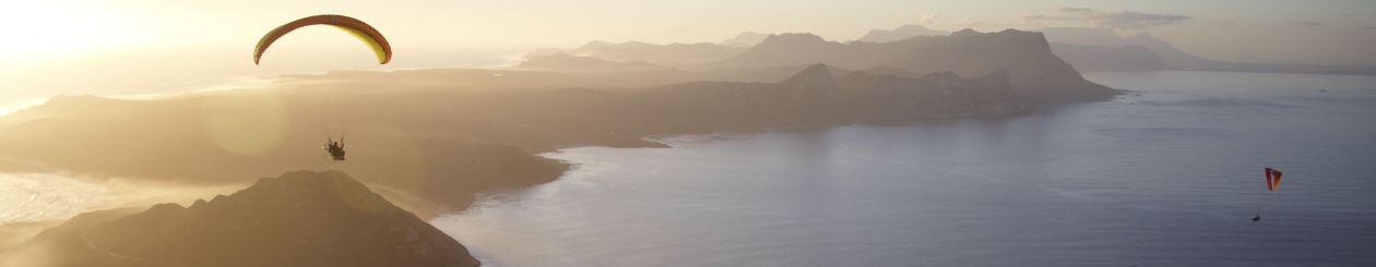
Sun City may be great, but nothing beats the Mother City on a beautiful day. This is the synonymous mountain across a peaceful Table Bay, taken from 1000ft while out getting some fresh air.
My good mate Ant of The Aerial Perspective was very kind to invite me along to Greyton, where he needed to take some pictures. We cruised out there in the Vito early this morning to find the town dead still (wind and street-life) with heavy dew on the ground, and so we stopped at a local coffee shop for tea and toast. Greyton is as pleasantly bucolic as I remember, albeit somewhat more developed these days.
Greyton from the air. Photo courtesy of The Aerial Perspective
After completing consumption of our comestibles we went looking for a launch area. The Greyton Sports Club had a nice field, but it was still very wet and surrounded on three sides by trees. A foray down the other end of town was more fruitful…well, too fruitful, in fact. Not only did we find a great little field, which was slightly raised and offered a puff of wind, but it was also downwind of the dump and sewage settlement ponds. To complete the scene, a large herd of splendidly flatulent bovines stood contemplating us from over the fence. Perfect. Although the field was small and the ponds large, the light wind was conveniently blowing across the corners, offering a decent run and space to climb out. We rigged quickly, and then I helped Ant launch so that he could get the photography done quickly. I was rapidly ready to go, and then in my enthusiasm flooded my engine and had to take if off to get it restarted. By that stage, the wind had almost disappeared, and what little remained was now blowing directly over the ponds, across the short axis of the already short field. Eish.
I have been nose-to-grindstone for quite some time, but the experience has been incredibly rich, with a number of firsts. Some of those stories will follow, I hope, but the blog takes a back seat at these times. Unfortunately, the flying has also been exceptionally sparse. In the absence of my own escapades, I stumbled across this video. It captures much of the essence of PPG in South Africa. Enjoy.
En septembre 2012, Cyril et moi sommes allés en Afrique du Sud pour visiter au sol, mais surtout pour survoler en paramoteur ce magnifique pays. Nous y avons rencontré des pilotes ayant un haut niveau de maîtrise de notre sport. Ces derniers nous ont grandement facilité la tache au cours de notre voyage et nous en sommes reconnaissant. L’Afrique du Sud est un pays offrant des paysages et une faune unique. Ce petit vidéo sans prétention relate quelques vols que nous y avons fait. C’était mon premier voyage dans cette région du monde et je ne souhaite qu’une chose, c’est d’y retourner.
In September 2012, Cyril and I went to South Africa to visit the country from the ground but also to fly with our paramotor over some magnificant places. We have met pilots with high skill level who help us along our trip through the country and we thank them. South Africa has a unique wildlife and landscapes to offer. This unpretentious little video present some flights that we have done. It was my first trip to this part of the world and the only thing I wish is to go back.
There’s been plenty of pressure and activity on the work front recently, which always results in an immediate decrease in flying opportunities. Consequently, over the last few months I’ve grabbed any chance to get airborne and do my favourite type of aviation: exploration. To discover new wild places from the air is a distinct thrill; changing seasons and the marks of man create new vistas in previously visited spots; even well-known areas release new secrets to a pair of curious aerial eyes. My new Ozone Speedster paramotor glider has rewarded me with some fantastic flights so far, including the maiden PPG flight in the Witteberg. While I’d love to write a dissertation on every one, the time escapes me, so as a compromise here are some quick vignettes with flight track logs and a few photos. I’ll provide links to the longer stories if and when I write them…
A flight of discovery in the remote Karoo replete with solitude, wildlife and tense fuel calculations becomes my best FAI triangle to date…
Flight track from Leonardo – click on the image to link to the story and track
Explorations 2 – Zandvlei
No firm plans, a whole big sky, and lots of familiar places to explore from a new perspective: I fly Muizenberg, the beach, mountain and wetlands, meet up with a flying friend for an aerial photo shoot, and end up with a 40km FAI triangle.
Click on the image to see the flight track log on Leonardo
Explorations 3 – Dolphin Beach to Atlantis Dunes
Any given Sunday with a westerly you can find PPG’s flying at Dolphin Beach near Blouberg. After enjoying the coastal dunes I head inland to Atlantis to play in it’s weird white-sand desert. It was an odd juxtaposition: sand-boarders, quad- and motorbikers, 4WD enthusiasts, a microlight and my PPG all weaving through the dunes.
Crankin’ & bankin’ in the Atlantis dunesClick on the image to see the flight track log on Leonardo
We were camping at the Khaya in the reserve with friends over a long weekend, and I grabbed the maiden flight for the area on the first evening just before sunset. The wind was very strong the next day, so we went on a 4WD trail instead, but our last morning dawned with a favourable forecast: Light southerly winds turning south-west later in the morning. I had planned a few routes to take advantage of all wind directions, flying into wind on my outgoing leg and then using a tailwind to return. The area is remote, with alternating mountain ridges and flatland valleys leading up to the Witteberge themselves. True to the Karoo, it’s a whole lot of desolation scattered with a handful of isolated farms; the mountains themselves have many hidden, trackless valleys. Not the sort of place you’d like to be stranded… but the rewards are great. Many of the old farms have been converted over the years to game farms and nature reserves; the WPNR and my planned flight path adjoin the Anysberg National Park. I packed spare water, energy bars, flares and survival kit and filled my tank to the brim. Launching at 3000ft above sea level with a heavily loaded and fully-fueled paramotor is not for the faint of heart, but the Ozone Speedster lifted off without difficult and carried me off into the unknown.
Departing the Witterberg Private Nature Reserve under my trusty Ozone Speedster
My first leg took me out through the southern end of the central valley of the WPNR into a beautiful flatland area. A few kilometers east I could see the boundary of the Anysberg National Park, and the land unrolling beneath me was soon dotted with curious springbok, twitching their tails in uncertainty as to whether I was a threat. I was flying into the gentle southerly, but with trims wide open maintained a comfortable 40 km/h ground speed. Although it was early, the sun breaking through patchy clouds was generating small thermals. This called for constant throttle adjustments; I tried flying at various levels but eventually settled for cruising at 300ft above ground and riding out the blips and dips. After 20 minutes of progression to the south I turned west along a valley, and was rewarded with views of some ruined native stone farmhouses and dilapidated kraals. As I crested a small neck and dropped into the lower section of the valley, a hefty eland bull regarded me with contempt while his two cows batted their ears.
Southwards into the wilderness
The valley widened out, and in the distance I could see a large farm replete with actual dirt road, in use. This was my first accessible bail-out point – after flying 50 minutes – and I checked my fuel carefully. I had been observing that the wind, forecast to be south or south-west, was very westerly for the section I had been flying, which was limiting my ground speed and increasing fuel burn. I wasn’t sure whether this was due to the topography or if the forecast was wrong, but my fuel situation was just acceptable: more than one-third into my planned route I had used 5 of my 14 litres supply. To be a little safer, I decided to shorten the route, and instead of flying all the way around the western end of the Witteberg range I’d climb through a valley 10km closer. Turning north, I ran low-level thorough a beautiful vlakte devoid of any sign of human influence. A startled group of rribbok cantered off on a tangent; a single massive but elegant gemsbok shook its long horns at me; I began to climb into the mountains.
Remote valleys filled with game underneath a cloud-dappled sky…
The westerly wind was blocked in the valley I entered, and in its absence the thermals had been building. Feeling the familiar lag of the wing dropping back as we entered a strong thermal, I throttled back in anticipation of the exit, but after a few seconds was still climbing. A brain-switch flipped; suddenly I wasn’t a paramotor pilot but an XC paraglider. Leaving the throttle I threw my weight over, pulled in the trims and was soon lazily circling at 1.8m/sec upwards in a beautiful morning thermal. What a pleasure…and good for fuel consumption! The bliss was prematurely terminated; reaching ridge-height the thermal rapidly became turbulent and then broke up. I checked my drift and realised the cause: the westerly wind was in fact a north-westerly that had been channeled along the valley, 90 degrees off the forecast direction. This was not good news: I was now 1h15 into my flight, had burned 9 litres, and still needed to fly across a head-wind for part of the route. Opening the trims again, I settled on the best course, angling to the only access road leading back to the reserve and then following it for the rest of the journey. A small herd of zebra ran along my path for half a minute as I overtook them, almost as if to offer encouragement. Reaching the road, I turned east along the valley and kept low, using the hills to funnel the wind into a tailwind. My fuel was receding into the last well at the bottom of the tank, but now I could see the mouth of Elandskloof and the WPNR ahead. I gave up on checking fuel and ticked off landing fields one by one as they passed below. Turning into the valley, I made a quick radio call: “Witteberg International, WMX approaching the field low-level from the north, requesting expedited landing runway 01.” I could hear the laughter in the background as my wife answered from the “tower” (a camp chair next to our tent): “WMX, land at your own discretion!” The Speedster deposited me gently through the turbulence, and I took a few minutes to enjoy the silence and smell of mountain fynbos before checking the fuel one last time. Just over a liter remained… but my tank of experiences was full to the brim.
Rock folds demonstrate the forces that formed the Witteberg Mountains as I cross over onto the northern end of the range.
Despite the shortened route (which proved, retrospectively, to be a very good decision) the flight track generated a 58km FAI triangle – my best yet.
Regular blog readers may recall that we travelled up to the Augrabies area on the Namibian border some weeks ago to take part in a shoot for the new Mazda BT-50 TV commercial. It was a long distance made oh-so-worthwhile by the chance to fly in and over the spectacular Riemvasmaak desert and through the Kai Garib gorge. After a long day of waiting, conditions finally allowed a launch about 2 hours before sunset, and we flew every last minute we could, generating hordes of footage… of which about 3 seconds makes it into the ad 😉
This is the ‘Making Of…’ video, which gives a good feel for the vibe, and features the commercial at the end. Would I do it again? Of course… you only live once 😉
Some photographs from the first PPG flight in the Witteberg Private Nature Reserve. I sneaked in the flight at sunset as the gusty daytime winds died off. By the time it came to launch, there was not a breath of wind. This was a serious test for my new Ozone Speedster – zero wind reverse launch at 3000ft ASL. The pictures tell the story. Credit to John Roos for the shots of me flying:
The old farmhouse, where a PPG-suitable take-off area is locatedPreparing the paramotor in the evening lightDressed for flightHelmet and comms on
Tom Lewis and Frik Linde have a dream, and have built a partnership to translate it into reality. After creating a very successful outdoor experience with 4×4 routes voted into the Top 10 in South Africa at Mont Eco near Montague, they clearly have the necessary skill. Their passion, however, is to make a true wilderness lifestyle accessible and sustainable to those who share their love of wild open spaces, black night skies lit only by the stars, and air tainted only with the fragrance of fynbos. The Witteberg Private Nature Reserve is the embodiment of the dream.
The Wittberg Mountains lie near the southern border of the Karoo within the Western Cape Province, South Africa. Readily accessible from the N1 national highway between Touwsrivier and Matjiesfontein, they are 2.5 hours drive (about 250km) from Cape Town. Like most of the Karoo, it is a harsh semi-arid area where large scale farming is tough and the terrain precludes expansive infrastructure. With an average altitude of around 1000m, it is a place of rugged fynbos-covered ridges interspersed with vlaktes, and secret kloofs. Bitterly cold in winter and scorching in summer, the beauty here is subtle and requires a shift in pace and perspective to appreciate. Frik’s family have farmed in the area for generations; indeed, the property which is now the nature reserve was once their land. They cultivated hardy salt bush in the valley to support ubiquitous Karoo sheep and later harvested the indigenous Proteas from the mountains, leaving gravestones, dry-stone wall enclosures and some whitewashed houses now reaching national monument status. Frik, however, joined in the endeavour by Tom, has had a different vision. Trading the vegetation-depleting sheep for naturally-occurring wildlife and converting the precipitous flower-harvesting trails into 4×4 routes, they have spent the last 5 years turning a farm back into a wilderness… and the result is breath-taking.