Tag Archives: kommetjie

Around Cape Point by Powered Paraglider

Yesterday yielded the opportunity to do one of the premier Cape powered paraglider flights – Cape Point. The Jettly PPG is an incredibly portable and versatile aircraft, but with a cruising speed of only around 25 knots and maximum sustainable speed peaking at 37 knots for the fastest XC wings, we need ideal wind conditions to attempt routes such as these. We have specifically been watching for forecast conditions that would allow a new first – flying around the peninsula, down one side and back up the other. To date all flights (only 4-5 other occasions that the flight has been successfully completed) have been exclusively along the western side. 30 April 2013 had a forecast for light ESE in the morning with light to moderate SW in the afternoon. As all pilots know, forecasts are completely trustworthy… or not.

Crossing Noordhoek towards Fish Hoek

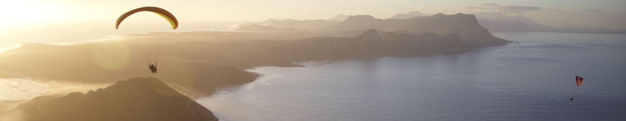
We launched in the late morning from Hout Bay in a very light breeze; anything helps when you are foot-launching with a full tank of fuel.  Climbing over the neck between Noordhoek and Chapman’s Peaks, we climbed steadily to 2000ft, and then overflew FAR139 (the controlled airspace around the Simonstown Naval Base) with pre-arranged permission.  The views flying south along the coast were beautiful; False Bay at peace with the encircling mountains hazy in the distance.

Paramotors over False Bay:  MDK (Powerplay Scorpio with Nirvana 190) and ANT (Ozone Speedster wit PAP Moster 185) flying south along the Cape Peninsula
Paramotors over False Bay: MDK (Powerplay Scorpio with Nirvana 190) and ANT (Ozone Speedster wit PAP Moster 185) flying south along the Cape Peninsula

The hands-off flying was rudely interrupted when we reached the end of the Klaasjagersberg ridge, however: an increasingly strong north-west breeze threw turbulent air off the peak and caused a few minutes of tachycardia.  Flying closer to Cape Point, it was apparent that the wind was persistently NW, and strong enough to cause pause for reassessment.   Prevented from flying lower by the restricted arispace over Cape P0int Nature Reserve, we crossed high from Diaz Cross to Diaz Beach to Diaz Point.  Feeling that discretion was better than a long lonely swim, we didn’t fly beyond the point in the northwest wind.

MDK at 2000' over Cape Point with False Bay in the background
MDK at 2000′ over Cape Point with False Bay in the background

A long and slow but beautiful flight back up the western side of the peninsula followed; only beyond the reserve could we dip down below the inversion at 1000ft and find the forecast southerly.  Climbing again from Kommetjie, we bypassed the long white sands of Noordhoek Beach and routed directly into Hout Bay with dwindling fuel supplies.  The breeze in Hout Bay on the ground was still SE and brisk enough to allow a three perfect landings on the doorstep of Dunes, where we were welcomed for a celebratory cold drink.

Crossing towards Hout Bay with Table Mountain in the far distance

A little over two hours flying, 75km distance covered, a fuel consumption of 9, 10 and 12 liters for the three paramotors = priceless new experience.

Track log on Leonardo.  More images below – click on a thumbnail to go to the slideshow.

Winter soaring bliss

Long Pete on the Aspen 4 overhead Judas Peak
Long Pete on the Gradient Aspen 4 overhead Judas Peak

UPDATED:  This time of the year (late August through to October) is one of the best for soaring flights along the Cape Peninsula and surrounding mountains.  As the frontal systems make their march to the south for the summer, the cold fronts lessen in intensity, with more more moderate prefrontal north-westerlies and lingering postfrontal conditions.  The air is cold and moist but the sun begins to reappear, leading to beautifully smooth soaring interspersed with the promise of good instability and thermal flying.  It is certainly the ‘high’ season for the Cape pilot’s classic route:  Signal Hill/Lion’s Head across to Table Mountain, southerly along the Twelve Apostles, and then back for sundowners or onwards into the lesser-flown for the brave (and those with dedicated retrieve drivers!).  For many years this route was more frequented by the hang-glider pilots with their better glide and speed range (the NW can exhibit a strong wind gradient as one climbs), but as paraglider technology has improved it is now achievable by pilots on almost any wing.  Come along on a tour, illustrated with my photos from today…

Continue reading Winter soaring bliss

I need your vote…

…in an initiative/competition run by Garmin. They are looking for stories of how people “Live Beyond” in various categories – outdoor, fitness, automotive, marine and aviation. I’ve entered our Cape Point paramotor flight in the aviation category, and now need votes. Click here to visit and vote for my entry at LiveBeyond.co.za

While you’re at it, why not add your own?

WildMedic on PPG over Cape Point
WildMedic on PPG over Cape Point - Photo copyright Ant Allen www.aerialphoto.co.za

Cape Point PPG Flight – First Photos

[singlepic id=296 w=480 h=360 float=center]

To date, only two people had ever done it: a powered paraglider flight around Cape Point, the “Fairest Cape of them all”, the Cape of Good Hope: the Cape of Storms. Today, that number was doubled. The Flying Ant (one of the original two) escorted Neil and I in a gentle, cold but perfectly smooth north-westernly on the flight down the peninsula to the very south-western tip of Africa. It’s a long way – the entire tip forms Cape Point National Park, meaning we have to launch north of the boundary and then fly at least 2500ft and offshore all the way – and the weather has to be perfect, but the incredible sights make it all worthwhile. A detailed story and many more photographs to follow, but here are some to whet your appetite:

[nggallery id=9]

Gratuitous flying

Apologies to people reading this who are not paraglider or hang-glider pilots… it may not make much sense (but then again, does your life make sense if you’re not a free-flying pilot?  Think about it…)

I was blessed with an actual day off today, and even more fortuitously one on which my wife is stuck in the hospital on call, so I could fly without any smidgen of guilt.  After consulting the wind gods (aka windfinder, windgurur, xcskies etc) I elected to head for Llandudno (aka Little Lion’s Head) so that any and all non-Sport rated pilots could join in.  Not wanting to miss the window of opportunity, come 09h00 this morning I was comfortably ensconced at a coffee shop on the Camp’s Bay beachfront, and soon thereafter joined by Niel Marx and his beau, Tessa.  Due to the entire lack of atmospheric air velocity, we breakfasted in style, interrupted only by calls from Gavin Ashwell and Ian Cowie seeking advice regarding our movements, and a surprise encounter with Ant Allen in his pink-and-white cycling tights.  (Fortunately I am a medical professional and was not too perturbed by this sight.)

Come 10h15 we decided that the skies had decided to shift from nothing to light NE, and therefore the progression to N then NW could be expected.  We embarked for Llandudno, leaving a car at the bottom, and headed up to launch.  Gavin planned to meet us there, but Ian and Ant elected to aim for a PPG flight at Soetwater (near Kommetjie) instead.

The short and pleasant stroll to take-off at LLH behind us, we found a strong breeze (perhaps 25km/h) at the mast, and after briefing Niel I suggested we move to the traditional takeoff, where it was a little lighter.  The wind was now a steady N.  I launched and climbed easily, spotting Gavin on his way to the takeoff.  Niel launched and was soon searing easily, but aloft it was evident that the expected NW wind gradient was in force, and he (sensibly, on a 1/1-2) elected to stay well in front of the mountain.  Gavin was soon climbing, too.

Due to my chronic itchyfootitis, I felt the compulsion to cross to Karbonkelberg, where the high north-facing cliffs promise easy lift to the wandering pilot.  Before long I was kicking my heels above 950m of clear winter air, watching Niel and Gavin fly out to land at Llandudno beach.  Both felt that their penetration was poor; I was in less compressed air (further from the Apostles) and still quite comfortable off speed-bar.  Trying to jump back to Little Lion’s Head, however, was not easy:  I lost 250m for little real progress and scuttled back to the lift at Karbonkelberg.


Clearly the very northerly wind precluded a run down the Apostles, so I was left with a choice:  try hard to get back onto LLH, perhaps landing at Sandy Bay in the process (hardly a hardship unless the old-and-wrinkly brigade was out in force), or try something I’d been itching to do for a long time:  go over the back into Hout Bay and fly further south.  A quick radio call to Niel/Tessa confirmed that they were willing to drive chase (Tessa does really like driving the Pajero), and so Plan B went into action.  I plunged into the best lift over Karbonkelberg on half bar and climbed up to 950m ASL before slipping round the corner into Hout Bay (see the panoramic picture – click on the image for much more detail).

The ride across the valley was swift and beautifully smooth, losing less than 200m altitude, and soon I could climb out again on the western flank of Constantiaberg.  From 900m again I set off over Hout Bay itself, giving Noordehoek Peak a very wide berth (to avoid eagle disturbance) and aiming directly for Chapman’s Peak.

Arriving at over 700m, I didn’t find much lift, and so put the northerly at my back and headed for Kommetjie.  I had a vague hope of getting onto Slangkop and from there to Misty Cliffs, but although I went overhead Kommetjie at 300m ASL this wasn’t enough height to get lift again, so I landed near the main road… about 500m short of bettering Abe Meyer’s distance record (who narrowly beat Ant Allen… it’s a cut-throat world in the South Peninsula).  Interestingly, if you look at the paths of my two last XC flights in the area (starting quite close but heading in opposite directions), both are almost exactly 22km.  Curious.

In any case, Tessa and Niel (bless them) were hot on my trail, and by taking a quick minibus ride I met them in Noordehoek.  (“Vyf Rand Vishoek toe, Meneer!”  “Wat as ek net Noordehoek toe wil ry?”  “Net vyf Rand dan, Meneer!”). Along the way I was cussed properly by every PG pilot who phoned to hear how the wind was (Not mentioning names: you know who you are).  It was by now blown out at LLH, but a light shone in the windy darkness:  Adam West (chairman of the HG club, for those not in the know) called and was enlivened to hear that the NW had appeared, and was headed to Signal Hill.  We deciede to go check it out.

Needless to say, wonderful flying was had at Sigs (several tandems also in attendance) before the wind backed off and left nothing else to do but raise glasses to a great day down at Mouille Point.  I still think I owe T&N more beers, but more is nog ‘n dag.